Removing Sediment to Restore Wetlands Clears Revenue Paths

In Brief
Real estate subdivision developers almost always want more land - and some are digging through the dirt to find it.
A wetland restoration method that clears sediment trapped for centuries behind dams can influence developers' project size and scope.
This approach found a pilot partner in Pennsylvania - and this story tells you what happened then.
A Note From the Editorial Team:
This news partnership among The Conservation Finance Network, Yale Center for Business and the Environment, and Highstead explores a range of financial projects with the goal of harmonizing capital, conservation, and social justice. This monthly publication usually prioritizes conservation models and case examples led by social and ecological outcomes. This article presents one illustration of how a conventional real estate developer incorporated floodplain restoration activities, an improvement on conventional practices, and their discrete benefits. It also shows other projects that aimed squarely at water quality improvements. Other ecological considerations associated with development were not explored as part of this story.
“My day job wasn’t to take care of watersheds,” said Eric Scott, Senior Vice President of Real Estate Operations for Oak Tree Development Group.
But watershed restoration became part of his firm's project budget, and drove up its revenue. In 2017, the real estate company began construction at Lime Spring Square, a 98-acre commercial and residential site in Lancaster, Pennsylvania. As part of the planning process, Scott and his team had to decide which Best Management Practices (BMPs) to implement to meet federal and state post-construction stormwater management requirements at the lowest cost. Persuaded by the promise of more developable land, Oak Tree opted for an innovative restoration approach called floodplain restoration. The idea was to improve the health of the site’s stream—and the valley bottom in which it flows—rather than focus on upland areas.
Four years later, the restoration at Lime Spring Square has proven highly stable and produced ecological benefits beyond the initial regulatory requirements. Visitors to the site today won’t see an engineered, golf course landscape of stormwater retention ponds and slopes carpeted in grass. Instead, they’ll find a clear stream, native plants, pollinators, and wildlife.
At Lime Spring Square, Oak Tree Development Group fulfilled federal and state stormwater mandates by restoring a wetland ecosystem. The wetland provides aesthetic and ecological functions and helps local and regional water quality. In ditching traditional practices such as swales, retention ponds, and dikes, Scott and his team chose to tackle an oft-overlooked but critical land-use legacy in the Eastern United States — the impact of historic dams.
Over the past decade and a half, Franklin and Marshall College geoscientists Drs. Dorothy Merritts and Robert Walter have challenged the conventional understanding of floodplains and streams throughout the Mid-Atlantic. The scientists realized that single-channel streams meandering through fine-grained floodplains had formed via rapid incision through sediment deposited in slack water reservoirs behind tens of thousands of mill dams.
Since this discovery, further research in the Mid-Atlantic, Northeast, and elsewhere has illuminated the environmental impact of the widespread damming of valley bottoms for hydropower from the 17th to early 20th Centuries. As settlers cleared uplands for agriculture, sediment flushed into valley bottoms, filling thousands of mill ponds across the landscape.
The instant a dam breached, the local water table dropped. Propelled by gravity, single-channel streams swiftly carved steep banks through this “legacy sediment”—a term Drs. Walter and Merritts applied to the anthropogenic sediment. What’s more, the construction of these dams in valley bottoms often submerged broad, natural wetlands. If you look closely, you’ll find evidence of these organic-rich wetlands near the water surface at the base of stream banks. Beneath what were once ponds but are now flat pastures and farm fields, layers of black, hydric soil lie buried under thick stacks of brown legacy sediment.
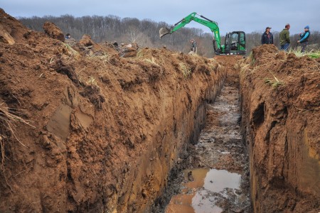
Dams and the mills they powered affected natural valley bottom hydrology in every corner of the Mid-Atlantic, including at Brubaker Run, the stream that meanders through the Lime Spring Square site. Prior to the restoration, Brubaker Run was flanked on the left and right by tall, near-vertical banks of fine-grained sediment visibly eroding into the stream. By the time the restoration was complete, the engineers had restored 4,750 linear feet of stream by removing 38,500 tons of legacy sediment that would have ultimately traveled downstream into the Chesapeake Bay. After engineers removed the sediment, 8.4 acres of wetlands that had persisted in the valley bottom for thousands of years reemerged.
Replacing barren, eroding pasture, the wetland at Lime Spring Square now provides aquatic and terrestrial wildlife habitat and associated ecosystem services. Riparian vegetation casts shade on the stream, decreasing water temperature. The removal of legacy sediment reconnected the ground surface to the natural groundwater table, enabling the mixing of groundwater and surface flow (which scientists call "hyporheic exchange"). This exchange decreases water temperature further and allows long-buried natural springs to support native aquatic life.
The wetland also reduces the rate and volume of stormwater runoff. Native wetland vegetation decreases water velocity and accommodates increased flood volume storage capacity, slowing the transport of pollutants downstream and reducing the threat of infrastructure damage during storm events. For Oak Tree, however, the choice of how to meet federal and state stormwater requirements came down to dollars and cents. From a development standpoint, a stream’s floodplain area is useless space. Yet, most traditional approaches to stormwater management despair of changing the floodplain and focus on upland acreage. The initial land plan at Lime Spring Square featured designs that any commercial developer would recognize. The designers proposed upland retention basins engineered to reduce the volume and rate of stormwater runoff from the development’s impervious surfaces.
As the team at Oak Tree moved forward with their land plan, however, Scott kept hearing from his contacts at the Lancaster County Planning Commission about an alternative approach to stormwater management that envisioned streams and floodplains as opportunities, not liabilities. Curious, he says he decided to meet with local environmental engineering firm LandStudies to consider an alternative plan featuring a floodplain restoration.
“The benefit didn’t become evident until two-thirds of the way through that meeting,” said Scott. But LandStudies eventually managed to convince him and his partners that they could fulfill their stormwater requirements without losing valuable land to large stormwater basins. “You’re left with these big basins that you can’t monetize, and you have to line them with twelve to twenty-four inches of amended soil, which is not cheap,” he explained. “I started to realize that doing a floodplain restoration and constructing basins was cost-neutral.”
The deciding factor for Oak Tree was that the stormwater benefits of floodplain restoration would be concentrated on the site’s least valuable land. They realized that through this approach they would gain 8.5 additional acres of developable land (roughly 9% of the total area of the site)—with an estimated gross value of nearly $1.9 million. For a restoration that cost $1.5 million, this added value represented a roughly 180% return on investment when compared to the initial restoration plan that would have cost the same amount but used those extra acres.
The Lime Spring Square restoration proved profitable to the developers, but it also saved money for local residents. Every year, the restoration removes 800,000 lbs of sediment, 5,773 lbs of nitrogen and 254 lbs of phosphorous from the waterway. According to LandStudies, these annual reductions equal what would be achieved by the construction of 64 miles of forested buffers on both sides of the stream. A buffer effort like that would cost taxpayers as much as $5.6 million.
Instead, East Hempfield Township surpassed its Municipal Separate Storm Sewer System (MS4) and Chesapeake Bay Total Maximum Daily Load (TMDL) commitments by receiving full credit for the load reductions from the restoration at zero cost to taxpayers. In fact, the extra developable land gained by the restoration stands to benefit residents through increased tax revenue to the township.
Beyond Lime Spring Square
Not every potential restoration site contains legacy sediment, and not every legacy sediment terrace buried a wetland. Even at sites with no identifiable wetland soil, however, legacy sediment removal has provided ecological and economic benefits. The 2014 floodplain restoration at Rock Lititz in Lititz, PA, for example, provides annual reductions of 248,000 lbs of sediment, 1,010 lbs of nitrogen, and 173 lbs of phosphorous, yet no historic wetland soil was ever identified. In addition to the nutrient load reductions, the change in floodplain geometry from the removal of legacy sediment improves the attenuation of peak stormwater runoff—a key to effective stormwater management.
The Rock Lititz restoration marked the first time the Pennsylvania Department of Environmental Protection permitted floodplain restoration as a stormwater BMP for a commercial development. Like Lime Spring Square three years later, Rock Lititz allowed a public-private partnership between a commercial developer and a municipality to meet stormwater and pollution reduction mandates.
Economically, Rock Lititz was a prelude to Lime Spring Square. The developable area of the Rock Lititz site increased from 47 to 56 acres—an estimated value of $3.1 million. Overall, the floodplain restoration and the economic benefit of this extra acreage resulted in a 182% return on investment.
Yet legacy sediment removal has remained outside the mainstream in the Mid-Atlantic. Even in Pennsylvania, where the first floodplain restoration was implemented at Big Spring Run in 2011, the approach is often not considered at sites where it could be applied. But that is changing, according to Conor Gillespie, founder of Catalyst Companies.
“More broadly, what we’re seeing in the restoration industry is a move towards floodplain-based, process-based restoration,” Gillespie asserts. He attributes this in part to a warming of the regulatory environment, which he says has come as a result of the long-term stability of a number of early floodplain restorations. “What really opens people’s eyes is when they see it in the field,” he said. “If they’ve worked on a project that’s failed and they see a floodplain restoration, that opens their eyes.”
At Big Spring Run in West Lampeter, PA, a decade of meticulous monitoring of the landmark floodplain restoration has opened many policymakers’ eyes to the long-term ecological benefits of legacy sediment removal. Prior to the restoration, the owner of the farm at Big Spring Run, Joe Sweeney, had tried planting thousands of trees to stabilize the eroding streambank only to watch 90% of them die. Their young roots could not penetrate deep enough into the thick stack of legacy sediment to reach groundwater. "Trees can't grow as fast as banks erode," says Sweeney.
The removal of legacy sediment at Big Spring Run in 2011 was the first stream restoration to truly address the impact of sediment trapped by historic damming. At many sites across the Mid-Atlantic, costly bank armoring and riparian buffer plantings fail—or prove unstable over time—because the sediment they are designed to immobilize should not have been there in the first place.
Where will this go? Regulatory reception of floodplain restoration varies by state. Some states are more resistant to any restoration approach that removes trees, which is sometimes necessary during legacy sediment removal. In Pennsylvania, however, floodplain restoration is codified as a stormwater BMP. According to Ben Ehrhart, Director of Design at LandStudies, who did the regulatory calculations and design plan for Lime Spring Square, “we are over the hump on the regulatory side in Pennsylvania.” Ehrhart noted that PA DEP and the Army Corps of Engineers are now actively advocating for legacy sediment removal and floodplain restoration.
"It takes a developer, willing or coerced...and a municipality looking to benefit."
While gaining regulatory approval for these restorations has gone from herculean to relatively streamlined over the past decade in Pennsylvania, Ehrhart emphasized that there is still a significant education process involved in convincing investors to move forward with this unorthodox approach. “It takes a developer, willing or coerced,” he half-joked, “and a municipality looking to benefit.”
Despite Oak Tree’s success at Lime Spring Square, Eric Scott admits that his company’s tolerance for risk may have been more than others would stomach. “We were unusual as a developer to take on something like this,” Mr. Scott acknowledged. “Not every real estate developer is built to understand it, and how to manage the risks—not just from a spreadsheet point of view, but from a relationship point of view.” He recognizes that without his connections at the planning commission, he and his team would never have considered floodplain restoration.
“It was extremely risky for us to undertake because of the time restrictions of (regulatory) approvals,” Mr. Scott emphasized. “We had leases in place with day-certain commitments to big national brands like Panera, Starbucks, and Chipotle. We wanted to make sure the approvals were done at a developer’s pace.” Scott claims that these risks were more palatable for a mid-sized real estate developer like Oak Tree than they may be for smaller “mom and pop” developers. “This is way off their radar screen,” he said. Bigger developers may also be less willing to pursue an uncommon restoration approach, particularly if there is regulatory uncertainty.
Still, Scott believes that - where applicable - removing legacy sediment and restoring floodplains will continue to benefit a developer’s bottom line. Motivated by their success at Lime Spring Square, Oak Tree Development Group is currently partnering with Penn State Health on another legacy sediment removal project on Swarr Run in East Hempfield Township. The floodplain restoration will fulfill stormwater requirements for a mixed-use development and provide load reduction benefits to the township. The project is expected for completion in summer 2022.
“A developer can get 10-15% more in leasable square footage on one of these projects,” says Scott. Yet he acknowledges there is an opportunity for a more consolidated marketplace. “There needs to be some centralized organization to put the ball on the tee for developers,” he insists. While the regulators in Pennsylvania and elsewhere are warming to the science and engineering behind floodplain restoration, Scott believes that regulatory changes alone won’t be enough to open the floodgates—to breach the dam, if you will.
While the taxpayers of East Hempfield Township benefitted financially from the privately funded restorations at Lime Spring Square and Rock Lititz, townships and municipalities elsewhere in Pennsylvania have reached into their own pockets and acquired public funding for floodplain restorations to meet regulatory mandates.
The restoration at Conewago Creek, which began in the summer of 2021, seeks to remove 125,000 cubic yards of legacy sediment from a valley bottom on the border of Lancaster and Dauphin counties. Londonderry and Mt. Joy Townships have partnered on the project, raising over $1.5 million in federal and state grants since 2017. The partnership between the two townships has enabled the project to achieve economies of scale on certain fixed costs. For example, both townships will receive credit for the stormwater and pollution reductions while combining permitting and bid implementation costs under one contract. The collaborative effort has also lowered construction, mobilization, and administrative costs.
When asked if it had been difficult to secure federal and state funding for a relatively uncommon restoration approach, Monique Dykman, Londonderry Township MS4 Environmental Specialist replied, “We don’t always fit the mold of some grant programs due to the nature of the project, so we have had to do a lot of explaining of its values to secure the funding we’ve received so far.” Part of that effort involved making a scientific case for legacy sediment removal.
During pre-restoration research, the Londonderry Public Works Department dug six soil pits to understand the extent of anthropogenic legacy sediment accumulation at the site. In one pit, organic material from 2.6-3.1 feet below the ground surface was carbon-dated to 110 years old, suggesting it accumulated during rapid legacy sediment deposition behind a historic dam. Organic material from a hydric soil horizon 5.3-6.1 feet deep, by contrast, returned a date of 6,357 years before the present.
The evidence suggests that once complete, the Conewago Creek restoration will restore a long-buried wetland. It will also connect a wildlife corridor that will help animals migrate, breed, and forage. Like other floodplain restorations in the region, it will reduce the risk of flooding through groundwater reconnection, riparian vegetation, and improved floodplain geometry.
“Most grant programs seem to like the project,” Ms. Dykman says, “but a lot of grants prefer to be the last money in to ensure [it] gets built.”